
Students who have participated in the GeoEngage program have created geoscience informative products for public education in local parks and college campuses. Check out these educational resources below.
Project 1: Where's All the Water?
Description: At NVC, three students worked with Government Canyon State Natural Area personnel to develop an audio tour for the park's Discovery Trail. The tour highlights the geologic setting of the park that forms part of the recharge zone of the Edwards Aquifer, which provides San Antonio's water supply.
Project 2: What Are Important River Features Along the Medina River?
Description: At The University of Texas at San Antonio, seven students worked with the San Antonio River Authority to develop scientifically informed signs for visitors to the new Henrick Arnold Nature Park.
- View prototype sign 1 (Hendrick Arnold Nature Park: Flooding)
- View prototype sign 2 (Hendrick Arnold Nature Park: Medina River Floodplain and Terraces)
- View prototype sign 3 (The River Geomorphology of Hendrick Arnold Nature Park)
- View prototype sign 4 (Protecting the Medina River Watershed)
Project 3: What's Under Your Feet at Northwest Vista College?
Description: At NVC, 19 students divided into five groups worked together to develop poster presentations about the geology on their campus for the science festival held on campus each semester. Access two of their presentations below.
- View poster 1 (Austin Chalk & Karst Invertebrate Species)
- View poster 2 (Surveying Austin Chalk for Karst Features)
Project 4: What's Under Your Feet at Palo Alto College?
Description: At PAC, 11 students divided into three groups worked together to write and publish a feature news story about the geology on their campus for the Pulse magazine, the student newspaper. Access one of their stories below.
Project 5: What Was the Environment Dinosaurs Lived in the San Antonio Area?
Description: At The University of Texas at San Antonio, eleven students worked with Government Canyon State Natural Area personnel and university faculty to develop a 3D digital model depicting the rock outcrop near dinosaur tracks along the Joe Johnston trail and explaining key geological features of this outcrop.
Check out the 3D model.
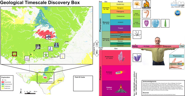
Project 6: What is the Age of Rock Formations in State Parks near San Antonio?
Description: At the University of Texas at San Antonio, seven students worked with Government Canyon State Natural Area personnel and university faculty to develop a board game that exposes visitors to the geological timescale. Using information on an ID card, participants to the game locate state parks on a geological map of central Texas, and place a 3D print of a fossil specific to that park along the geological timescale.
Disclaimer
This material is based upon work supported by the National Science Foundation under Grant Number 2119446. Any opinions, findings, and conclusions or recommendations expressed in this material are those of the author(s) and do not necessarily reflect the views of the National Science Foundation.
